Profinder Pro Chip

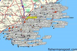
A screenshot of ProFinder’s Wilmington Pro Chip with over 325 waypoints spanning from Little River to Cape Lookout.
It’s the most basic, yet one of if not the most important question on the minds of both rookie and experienced saltwater anglers—Where do I go fishing?
Outside the inlets, where visual landmarks provide little to no assistance, the subject becomes even more daunting. Enter the ProFinder Charts Pro Chip.
Each Pro Chip covers around 150 miles of the Atlantic or Gulf Coast and contains 325+ waypoints for prime fishing spots ranging from artificial reefs and wrecks to live bottoms and ledges.
“All gamefish relate to structure,” ProFinder’s John McWhite explains. “No matter what kind, it attracts bait fish, and there the food chain starts. Having accurate coordinates for various structure is the key to catching fish, and our data puts you in the right location.”
McWhite began ProFinder by taking his field artillery and golf course design background to the sea when he realized there wasn’t a good fishing chart for his local waters off Ocean Isle Beach. So he created one—the first ProFinder Fishing Chart. Demand grew outside the local area, and charts for most of the South Atlantic and Gulf Coast were soon to follow.
McWhite still makes the charts, and the appropriate one comes with every Pro Chip, but the Pro Chips enable anglers to import all the waypoints on the charts directly to their GPS unit, saving what would be far too many tedious hours of manually entering the coordinates.

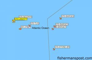
A close up of the popular Liberty Ship area, AR-370 off Wrightsville Beach, showing some of the components of the reef, several sunken barges, a tugboat, and the Liberty Ship Alexander Ramsay.
The chips are available for virtually all brands and models of GPS units that have a port for memory cards, and ProFinder now offers a chip covering any of the coastal and offshore waters from Long Island to Louisiana.
McWhite collected his data through hundreds of hours studying bathymetric mapping software and extensive collaboration with divers, commercial fishermen, authors, and others. The waypoints are proprietary coordinates whose accuracy has been extensively verified, and McWhite offers the eight SKA Champions and five Angler of the Year winners using Pro Chips as proof that they’re the real deal.
Inputting the Pro Chip’s data into a GPS is extremely simple, but McWhite provides step-by-step instructions for all modern units and offers his cell phone number to anyone needing any assistance.
“We try to make a point of talking to each of our clients,” he says. “The world of GPS is quite complicated, and we have the knowledge and expertise to determine how we can simplify using their marine electronics.”
A Pro Chip is also a lifetime purchase, as he’ll facilitate anglers who switch boats or brands of electronics to get not only the Pro Chip waypoints, but all their other stored data into each electronics manufacturer’s specific format and loading the data into a new machine.
Interested anglers can get more information and purchase Pro Chips from www.profindercharts.com and www.davyhiteprochip.com, and they can also be found locally at Ocean Isle Beach’s The GPS Store and Ocean Isle Fishing Center.
