Product Review: SiriusXM Marine
The age-old question all offshore anglers ask themselves before heading out to sea is, “Where should I go?” Evaluating temperature, altimetry, and chlorophyl charts in the days preceding a trip has been a staple in trying to locate fish, and those efforts give the best chance to have successful days on the water.
Once choosing a location, the “hope” of finding a significant weed line, rip, or eddy is vital. However, a new piece of technology has hit the market that combines all this data into one tidy system… Fish Mapping by SiriusXM Marine has arrived. There is now “More Fishing. Less Guessing.”
It is nice to have a plan based on factual and accurate technology of where to travel and what species to target. Whether competing in a tournament, out fishing for fun, or taking clients on a charter trip, Fish Mapping was developed to provide information needed to help get to the spots where the targeted species is most likely to be located.
Time and fuel savings are critical, and this new service provides an advantage never seen before in an all-in-one service. Some of the features included are very refreshing to have immediate access to and certainly change the game when headed offshore.
Fishing Recommendations: This tailored information helps find the targeted species much faster. Viewing recommendations combined with other Fish Mapping features on the multi-function display helps zero in on where to fish.
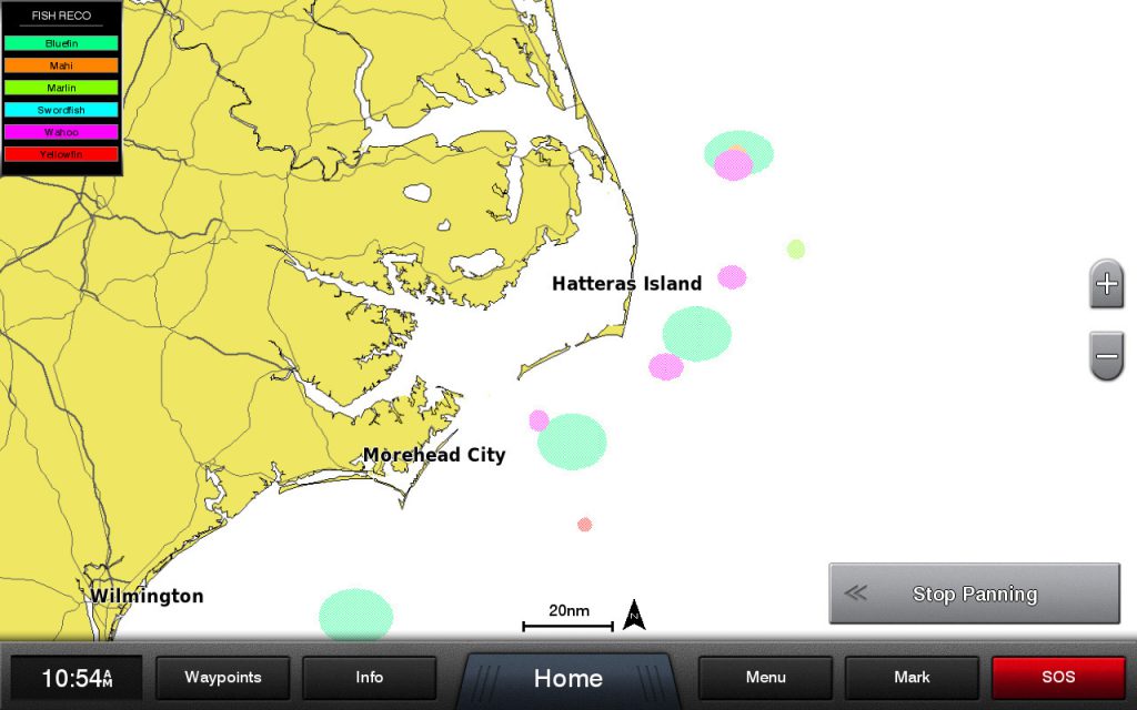
A SiriusXM Marine screenshot showing Fishing Recommendations: a program showing where different species are most likely to be caught based on the ideal oceanographic conditions for each species.
Weed Lines: We all know that weed lines drift and shift as ocean current and winds shift and change. Therefore, they can be difficult to locate. Using this feature will help find where weed lines have been sighted recently or are most likely to be forming.
Sea Surface Height Anomaly: “Upwellings” create desirable target location because of the nutrient-rich water that pushes up the water column and attracts baitfish and gamefish. This feature also can be used to avoid “downwelling” areas that are nutrient-poor and not as attractive.
Sea Surface Temperature Contours: The ability to locate the simplified contour lines with this function allows you to quickly find water temperatures in the targeted area.
Sea Surface Front Strength: Fishing always seems to be better just before steep temperature changes or “fronts” reach an area. Locating areas where both temperature and plankton fronts join can produce epic catches.
30m Subsurface Sea Temperatures: Various species of fish prefer specific ranges of temperatures, and this feature identifies areas with the preferred temperature range of the target gamefish in the area below the surface where they are likely to be hunting.
Plankton Concentration Contours: Quickly locating the areas that plankton will congregate provides an advantage when being able to find this on the multi-function display. This feature is extremely helpful in identifying favorable conditions for the target species.
Plankton Front Strength: A feature that shows strong plankton fronts will help indicate where nutrient-rich water that draws baitfish occurs next to clear, predator-preferred water.
A lot of money is spent on fishing boats, equipment, bait, and accessories, all to have fun and hopefully be successful. The Fish Mapping subscription package is only $99.99 per month, and it includes fishing data and all the SiriusXM Marine Offshore package weather features (a $59.99/mo value). This is a small investment to help be more successful on the water and return to the dock safely with bragging rights, great table fare, and incredible memories.
SiriusXM Marine has made trying Fish Mapping simple and risk-free. There is a free, one-month trial that can be enjoyed by calling (844) 342-0665. Once subscribing to the service, one of the most convenient features offered is the ability and option to suspend it for up to 6 months, once per year, at no additional cost. This allows the service to be shut off and turned back on without having to cancel the subscription when it is off-season.
As anglers, what does this really mean? In addition to the SiriusXM Marine weather information, the fact is that other fishing data services charge for each piece of data; however, you can have the best, most up-to-date fishing information at your fingertips and right on the boat’s display while headed out to fish up to 200 miles offshore. It is available before and during the trip, and not just the night before or when leaving the dock.